Events Calendar
Current Weather
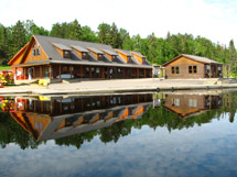
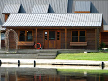
Lake Opeongo Access Point (#11) 
| As of April 1, 2026, Ontario Parks has permanently closed the Lake Opeongo Access Point Office. Visitors needing in-person services are encouraged to use the West Gate or East Gate. |
Location
At km 46.3 of Highway 60, follow the Opeongo Road (paved) north for 6.2 kilometres to the access point at the southern end of Lake Opeongo. Latitude and longitude of Access Point: 45.635804°, -78.360447°
During winter, the Opeongo Road is typically open and plowed to the winter gate just south of the Cameron Lake Road intersection (approximately 2.5 km north of Highway 60). Other related services are closed during the winter (see below).
Facilities
Access Point Office(permanently closed as of April 2026)- Parking
- Toilets
- Shower facilities
- Telephone
- Boat launch ramp
- Opeongo Store
- Harkness Lab Fish Check Station
Backcountry Permits
Make a reservation for your backcountry camping permit up to 5 months in advance. Permits are only available online or via telephone.
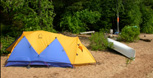
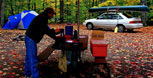
Equipment Rental
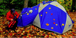
Do you need to rent a canoe, tent, or other camping equipment? Find a business that can supply some or all of the required equipment for your backcountry trip.
Water Levels
Check for special advisories prior to your departure at Algonquin Park Advisories.
Related Information
 West Gate
- East Gate
 Algonquin Visitor Centre
 Big Crow Ranger Cabin
- Kitty Lake Ranger Cabin
- Tattler Lake Ranger Cabin
- Backcountry Canoeing
- Canoe Routes Map - Explore Online
Reserve your developed or backcountry campsite for your next visit.


Share your passion for Algonquin Park by becoming a member or donor.

Special regulations for Algonquin's special fishery.